Wedgemount Lake Hiking Guide

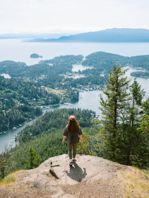
Just north of Vancouver, between Squamish and Whistler, sits Garibaldi Provincial Park – one of the most beautiful hiking destinations in British Columbia. The most popular trail in the park is Panorama Ridge, but another route worth exploring is the Wedgemount Lake trail, home to two turquoise lakes, glaciers and stunning mountain views. The trail climbs around 1300 meters so it’s best for experienced hikers, but no doubt it’s worth the effort. It also happens to be one of the most sought after camping locations near Vancouver.

Planning considerations:
DISTANCE
14 km return
MOVING TIME (MODERATE PACE)
6 – 8 hours
ELEVATION GAIN
1300 m
DIFFICULTY
Hard
Wedgemount Lake trail overview
The forest
Almost immediately after the parking lot, you’ll cross a bridge and enter the forest. This part of the hike is full of rocks and roots but not technically difficult. The challenge is the steepness of the trail. Along the way, you’ll have to cross a couple of boulder fields. First a small one and then a much bigger one further up at around 1,450 m of elevation. Although there are no switchbacks, for the most part the hike is forested and lacking in views until you reach the scramble.


The scramble
At first glance, the final section to the lake looks downright intimidating. Like a near vertical wall of massive rocks and boulders. But as you get closer, you’ll notice a clear path and there are only a few spots where you’ll need to use your hands to scramble. There’s no exposure and no technical scrambling skills required on the way up. Negotiating the same section on the way down is a lot more awkward due to the steepness, but as long as you take your time, you’ll be fine. It’s not your typical mountain trail, but it’s not a pure scramble either. Just enough to keep it interesting.


If you look closely you can see hikers scrambling up between the boulders to give you a sense of scale. 
This is the screaming marmot we mentioned earlier 🙂 


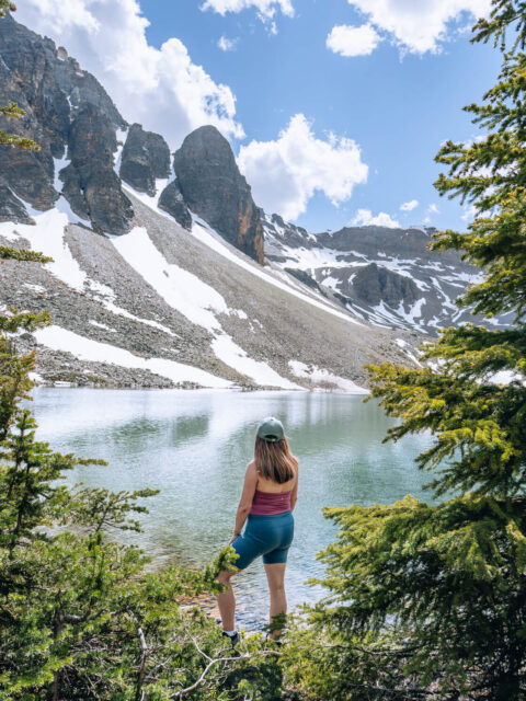
Wedgemount Lake
As you reach the top of the scramble, you’ll forget all your pain! Mount Cook, Mount Weart and Armchair Glacier look absolutely amazing from this spot! From here, the trail is mostly flat and very soon you’ll reach Wedgemount Lake. It’s hard to describe the feeling of being there as the sight of Wedgemount Lake paired with the mountains is simply breathtaking
There is a path along the lake and you can choose how far you want to explore.
It’s worth knowing that the appearance of the lake can vary depending on the time of year and the weather. During our hike on a partially cloudy day at the end of July, the water had a nice teal colour but it was somewhat muted. On a sunny day, it would look much more vibrant.
Even though the trail is popular and there are tents scattered around the lake, there’s enough space to find a spot where you feel like there’s no one else around. We had our lunch here, took a lot of photos (it’s hard not to!) and then started heading towards the second lake.
Tupper Lake
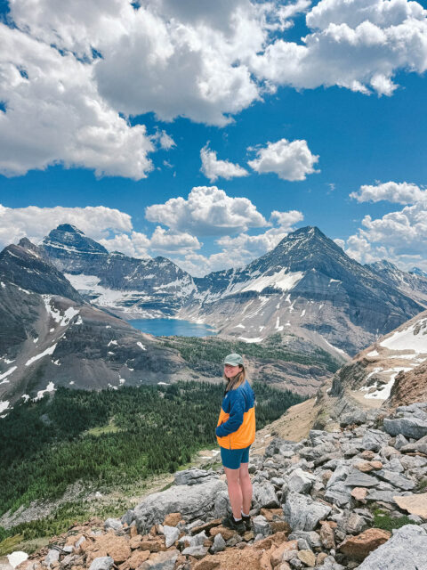
You can follow the path along Wedgemount Lake and then head uphill a bit to reach Tupper Lake (the second lake). It’s much smaller and not as picturesque as Wedgemount Lake, but it’s still beautiful and you’ll be much closer to the Wedgemount Glacier. If you’ve got time and the conditions are good, you can try hiking further up to check out the glacier up close and maybe even find some ice caves. You’ll also get a nice view of the first lake from up there. Just keep in mind that hiking on glaciers and exploring ice caves can be dangerous, so if you’re not experienced, it’s best to admire from a safe distance.
The disappearing Wedgemount Glacier
When we were searching for information about the Wedgemount Glacier, we stumbled upon a photo from 2005 showing the outline of what would eventually become Tupper Lake, except back then, the lake didn’t even exist. The photo was taken by Karl Ricker, who has been monitoring the glacier for nearly 50 years. What blew our minds was learning that the Wedgemount Glacier used to extend all the way to Wedgemount Lake, but since Karl started his research, it has receded by more than half a kilometer. Mountain glaciers are disappearing fast, and Wedgemount is no exception. It’s a stark reminder that the planet is warming, and it’s sad to think that one day the Wedgemount Glacier could be gone entirely.
If you’re interested in this topic, you can find more information on the Whistler Naturalists website.

Wedgemount Lake Personal Highlights: Blue Lakes, Glaciers and Shouting Marmots
Wedgemount Lake was one of our first hikes in Canada and it immediately stood out as something special. The trail was steep and physically demanding, but when we finally reached the top and climbed to the first viewpoint of the lake, we were left speechless as we had never seen a lake with such an intense blue colour before.
What struck us even more was the unexpected burst of colours around the lake: the blue water paired with patches of pink and yellow flowers looking like something straight out of a postcard. You can somewhat see it in the photos, but of course, no camera can capture how beautiful it looked in person.
And then there was the glacier at the second lake (Tupper Lake). For many visitors – ourselves included – it’s the first time standing beside one at eye level. The scale is humbling and we were completely fascinated.
But perhaps the most unexpected highlight of the hike was hearing strange, loud screams that we thought were other hikers. It wasn’t until later that we realised they were marmots. Seeing these animals sitting on rocks and yelling into the void was quite amusing, but hearing those sounds at night might give you a real scare if you didn’t know what they were.


Wedgemount Lake Hike FAQ
Where to park for a hike to Wedgemount Lake
The best parking option is the designated Wedgemount Lake parking lot, but make sure your vehicle is ready for a VERY bumpy gravel road. You shouldn’t need a 4×4, but having higher clearance will definitely help. We saw all kinds of cars in the parking lot including an EVO, but personally we wouldn’t risk it with a low ground clearance vehicle.
To get to the parking lot, exit onto Gravel Pit Road from the Sea to Sky highway, go left at the fork and then right onto the Wedge Creek Forest Service Road.
If you can’t make it to the parking lot, you can park by the Gravel Pit Camping site or along the Wedge Creek Forest Service Road road, but this will add up to 2 extra kilometres and 200 vertical meters to your hike! Trust us, you’ll regret it on the way down!
How long is the Wedgemount Lake hike?
The hike is at least 14km round trip, despite the AllTrails app saying it’s 11km. When we did it, it ended up being almost 18km because we spent a lot of time walking around both lakes and taking photos.
How difficult is the Wedgemount Lake hike?
The hike is a grueling uphill grind, ascending around 1,300 vertical meters through tree roots and boulders, so be prepared for a solid workout. As moderately fit day hikers, we’d rate this hike as moderate to hard, but if we had to carry a heavy overnight backpack, there’s no doubt we’d call it hard.
Going down is worse than going up, as it’s hard on your knees due to the steep terrain and the somewhat slippery surface which includes loose dirt, gravel and small rocks.
When is the best time to hike to Wedgemount Lake?
The best time to hike to Wedgemount Lake is from July to September. Outside of this window, the hike is significantly more challenging due to ice and snow, not to mention the avalanche risk. Unless you have serious hiking experience and you’re trained in avalanche safety, it’s best to avoid this trail in the off-season.
Do I need hiking poles?
Hiking poles are not essential for the Wedgemount Lake trail, it is 100% possible to do it without them. However, using them is guaranteed make your hike a lot easier, especially on the way down.
Is there drinking water on the trail?
Yes! This is not the hike to not have water or have too little. If you’d rather not carry a heavy supply, bring a water filter as you can refill at the lake at the top.
What’s the toilet situation?
There is a basic pit toilet at the official car park and another one near the Wedgemount Lake Hut at the lake. Make sure to bring your own toilet paper.
Can I bring my dog?
No, dogs are not allowed on the Wedgemount Lake trail or any other trails within the Garibaldi Provincial Park.
Can I expect to see any wildlife while hiking the Wedgemount Lake?
Yes! We spotted a few grey jays, chipmunks, squirrels and a marmot, and of course, it’s possible to encounter bears so make sure to carry bear spray with you. There are other large mammals here according to the BC Parks website, such as deer, mountain goats, cougars and wolverines, but they are not that common.
How cold is it at the lake?
The lake is 1,875 metres so definitely bring some extra layers as it can get chilly and windy, even on a sunny day.
Can I camp at Wedgemount Lake?
Yes! There are two designed campsites near the lakes, each with 10 wooden tent pads. Both require a camping reservation. You can make a reservation up to four 4 months in advance through the BC Parks reservations system. A reservation secures you a spot, but not a specific tent pad.
There’s also the Wedgemount Lake Hut which can sleep up to eight people, but it’s reserved for public safety and emergency situations only. In other words, you shouldn’t plan to stay in the hut and leave your tent at home.


Got more questions about the hike?
This hike is 100% worth doing! It’s challenging but incredibly rewarding. If you have any questions about the trail or other hikes in Garibaldi Provincial park, drop us a message in the comment section below and we’ll be glad to help!